
You are using an out of date browser. It may not display this or other websites correctly.
You should upgrade or use an alternative browser.
You should upgrade or use an alternative browser.
st mary tornado warning 731pm
- Thread starter penguin6
- Start date
MrX
High Octane
penguin6
New Member
are you sure? Thought he said tornado, but would be glad if I was wrong
R
remaxrealtor
Guest
i heard the siren too but its calm, people outside, and all the ducks in the pond here off chancelors run.
Are we on the same pond? LOL! I'm off Chancellor's Run!
R
redhotmomma
Guest
I am in Westbury. It just seems weird out.
dn0121
New Member
Are we on the same pond? LOL! I'm off Chancellor's Run!
meadow lake
Urgent - Immediate Broadcast Requested Tornado Watch Number 454 Nws Storm Prediction Center Norman OK 735 PM EDT Wed Jun 4 2008
The Nws Storm Prediction Center Has Issued A Tornado Watch For Portions Of
District Of Columbia Delaware Parts Of Eastern Kentucky Parts Of Maryland Parts Of Southern New Jersey Parts Of Southern Ohio A Large Part Of Virginia A Large Part Of West Virginia Coastal Waters
Effective This Wednesday Night And Thursday Morning From 735 PM Until 100 AM EDT.
Tornadoes... Hail To 2 Inches In Diameter... Thunderstorm Wind Gusts To 70 Mph... And Dangerous Lightning Are Possible In These Areas.
The Tornado Watch Area Is Approximately Along And 55 Statute Miles North And South Of A Line From 50 Miles West Northwest Of Huntington West Virginia To 40 Miles East Northeast Of Wallops Virginia. For A Complete Depiction Of The Watch See The Associated Watch Outline Update (wous64 Kwns Wou4).
Remember... A Tornado Watch Means Conditions Are Favorable For Tornadoes And Severe Thunderstorms In And Close To The Watch Area. Persons In These Areas Should Be On The Lookout For Threatening Weather Conditions And Listen For Later Statements And Possible Warnings.
Other Watch Information... This Tornado Watch Replaces Tornado Watch Number 447... Tornado Watch Number 449... Tornado Watch Number 450. Watch Number 447 449 450 Will Not Be In Effect After 735 PM EDT. Continue... Ww 448... Ww 451... Ww 452... Ww 453...
Discussion... Severe Thunderstorms Continue To Develop/Move Ewd Across Watch Area... Primarily Focused On Boundaries From Previous Activity. With Shear Remaining Favorable And Mlcapes To 2000 J/Kg S Of Boundaries... Damaging Winds And Possible Tornadoes Will Continue To Be Associated With Both Lines And More Descrete Storms.
Aviation... Tornadoes And A Few Severe Thunderstorms With Hail Surface And Aloft To 2 Inches. Extreme Turbulence And Surface Wind Gusts To 60 Knots. A Few Cumulonimbi With Maximum Tops To 500. Mean Storm Motion Vector 26035.
... Hales
MrX
High Octane
are you sure? Thought he said tornado, but would be glad if I was wrong
I posted the tornado warning in that thread since thats been active for quite a while.

R
remaxrealtor
Guest
meadow lake
Just through the wonds...Hayden Green!
 Hi neighbor, stay safe!
backagain39
New Member
Urgent - Immediate Broadcast Requested Tornado Watch Number 454 Nws Storm Prediction Center Norman OK 735 PM EDT Wed Jun 4 2008
The Nws Storm Prediction Center Has Issued A Tornado Watch For Portions Of
District Of Columbia Delaware Parts Of Eastern Kentucky Parts Of Maryland Parts Of Southern New Jersey Parts Of Southern Ohio A Large Part Of Virginia A Large Part Of West Virginia Coastal Waters
Effective This Wednesday Night And Thursday Morning From 735 PM Until 100 AM EDT.
Tornadoes... Hail To 2 Inches In Diameter... Thunderstorm Wind Gusts To 70 Mph... And Dangerous Lightning Are Possible In These Areas.
The Tornado Watch Area Is Approximately Along And 55 Statute Miles North And South Of A Line From 50 Miles West Northwest Of Huntington West Virginia To 40 Miles East Northeast Of Wallops Virginia. For A Complete Depiction Of The Watch See The Associated Watch Outline Update (wous64 Kwns Wou4).
Remember... A Tornado Watch Means Conditions Are Favorable For Tornadoes And Severe Thunderstorms In And Close To The Watch Area. Persons In These Areas Should Be On The Lookout For Threatening Weather Conditions And Listen For Later Statements And Possible Warnings.
Other Watch Information... This Tornado Watch Replaces Tornado Watch Number 447... Tornado Watch Number 449... Tornado Watch Number 450. Watch Number 447 449 450 Will Not Be In Effect After 735 PM EDT. Continue... Ww 448... Ww 451... Ww 452... Ww 453...
Discussion... Severe Thunderstorms Continue To Develop/Move Ewd Across Watch Area... Primarily Focused On Boundaries From Previous Activity. With Shear Remaining Favorable And Mlcapes To 2000 J/Kg S Of Boundaries... Damaging Winds And Possible Tornadoes Will Continue To Be Associated With Both Lines And More Descrete Storms.
Aviation... Tornadoes And A Few Severe Thunderstorms With Hail Surface And Aloft To 2 Inches. Extreme Turbulence And Surface Wind Gusts To 60 Knots. A Few Cumulonimbi With Maximum Tops To 500. Mean Storm Motion Vector 26035.
... Hales
Now its gonna be allllll night?????
dn0121
New Member
Just through the wonds...Hayden Green!
you too, i see kids and there parents outside and hear someone mowing their lawn.
Now its gonna be allllll night?????
That is what the weather service is reporting.

Doug Hill just broke on Channel 7 with emergency report, they are very concerned about St. Mary's County along the Potomac. This storm is expanding according to Doug Hill.
getbent
Thats how them b*tch's R
Weather.com says
Tornado Warning
TORNADO WARNING NATIONAL WEATHER SERVICE BALTIMORE MD/WASHINGTON DC 721 PM EDT WED JUN 4 2008
THE NATIONAL WEATHER SERVICE IN STERLING VIRGINIA HAS ISSUED A
* TORNADO WARNING FOR... ST. MARYS COUNTY IN SOUTHERN MARYLAND...
* UNTIL 815 PM EDT
* AT 718 PM EDT...NATIONAL WEATHER SERVICE DOPPLER RADAR INDICATED A SEVERE THUNDERSTORM WITH STRONG ROTATION 25 MILES WEST OF PINEY POINT...MOVING EAST AT 40 MPH.
* LOCATIONS IMPACTED INCLUDE... CALLAWAY... GREAT MILLS... VALLEY LEE... DRAYDEN... PARK HALL...
IF YOU ARE NEAR THE PATH OF THIS STORM...TAKE COVER NOW! IF NO UNDERGROUND SHELTER IS AVAILABLE MOVE TO AN INTERIOR ROOM ON THE LOWEST FLOOR. MOBILE HOMES AND VEHICLES SHOULD BE ABANDONED FOR MORE SUBSTANTIAL SHELTER. AVOID WINDOWS!
That is what the weather service is reporting.
Doug Hill just broke on Channel 7 with emergency report, they are very concerned about St. Mary's County along the Potomac. This storm is expanding according to Doug Hill.
Just came back from checking the river front


My mom wants me to go to my sisters where they are all at
I'm not driving in this to her house, I'll hide in the bathroomIf I don't post, tell the mail lady to go to OC without me

Baja28
Obama destroyed America
Turn on ABC 7. Severe rotation all around Fred.burg, tornado confirmed touch down, heading MY way!!That is what the weather service is reporting.
Doug Hill just broke on Channel 7 with emergency report, they are very concerned about St. Mary's County along the Potomac. This storm is expanding according to Doug Hill.

cashncarry
New Member
The tornado warning siren just sounded in Lexington Park. People came running out into their yards asking, "What is that? I've never heard it before." Well' it's a siren and it's thundering and lightnening all around. Can't be good. DUH They continued work on installing their dish antenna on a roof. No problem. Dumbazzes! If the train sound were to take place prior to a tornado touching down we'd never hear it in Lex. Park over the booming car steroes! Phone service and Metro Cast is okay here however in Hollywood my daughter's cell and land line are out of commission.you too, i see kids and there parents outside and hear someone mowing their lawn.
ALERT 1 - Tornado Warning
TORNADO WARNING FOR, SOUTHWESTERN PRINCE GEORGES COUNTY IN CENTRAL MARYLAND, NORTHEASTERN KING GEORGE COUNTY IN CENTRAL VIRGINIA, EXTREME SOUTHEASTERN FAIRFAX COUNTY IN NORTHERN VIRGINIA, SOUTHEASTERN PRINCE WILLIAM COUNTY IN NORTHERN VIRGINIA, EAST CENTRAL STAFFORD COUNTY IN NORTHERN VIRGINIA, CHARLES COUNTY IN SOUTHERN MARYLAND, NORTHWESTERN ST. MARYS COUNTY IN SOUTHERN MARYLAND, UNTIL 815 PM EDT
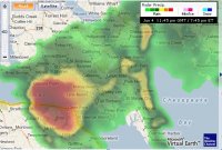
Issue Time: 7:41PM EDT, Wednesday Jun 4, 2008
Valid Until: 8:15PM EDT, Wednesday Jun 4, 2008
Back to summary
Bulletin - Eas Activation Requested Tornado Warning National Weather Service Baltimore MD/Washington DC 740 PM EDT Wed Jun 4 2008
The National Weather Service In Sterling Virginia Has Issued A
* Tornado Warning For... Southwestern Prince Georges County In Central Maryland... Northeastern King George County In Central Virginia... Extreme Southeastern Fairfax County In Northern Virginia... Southeastern Prince William County In Northern Virginia... East Central Stafford County In Northern Virginia... Charles County In Southern Maryland... Northwestern St. Marys County In Southern Maryland...
* Until 815 PM EDT
* At 735 PM EDT... A Tornado Was Reported By National Weather Service Skywarn Spotters Near The Intersection Of Interstate 95 And State Route 17 One Mile North Fredericksburg... Moving East At 50 Mph. A Tornado On The Ground! This Is A Life Threatening Situation... Take Cover Now!
* Locations Impacted Include... Indian Head... La Plata... St. Charles...
A Tornado Has Been Confirmed! If You Are Near The Path Of This Tornado... Take Cover Now! If No Underground Shelter Is Available Move To An Interior Room On The Lowest Floor. Mobile Homes And Vehicles Should Be Abandoned For More Substantial Shelter. Avoid Windows!
Lat... Lon 3836 7673 3836 7699 3844 7703 3841 7707 3836 7700 3836 7701 3836 7714 3840 7707 3840 7708 3836 7722 3842 7728 3856 7725 3845 7732 3835 7728 3835 7735 3850 7731 3851 7739 3864 7741 3872 7681 Time... Mot... Loc 2340z 271deg 45kt 3849 7730
TORNADO WARNING FOR, SOUTHWESTERN PRINCE GEORGES COUNTY IN CENTRAL MARYLAND, NORTHEASTERN KING GEORGE COUNTY IN CENTRAL VIRGINIA, EXTREME SOUTHEASTERN FAIRFAX COUNTY IN NORTHERN VIRGINIA, SOUTHEASTERN PRINCE WILLIAM COUNTY IN NORTHERN VIRGINIA, EAST CENTRAL STAFFORD COUNTY IN NORTHERN VIRGINIA, CHARLES COUNTY IN SOUTHERN MARYLAND, NORTHWESTERN ST. MARYS COUNTY IN SOUTHERN MARYLAND, UNTIL 815 PM EDT
Issue Time: 7:41PM EDT, Wednesday Jun 4, 2008
Valid Until: 8:15PM EDT, Wednesday Jun 4, 2008
Back to summary
Bulletin - Eas Activation Requested Tornado Warning National Weather Service Baltimore MD/Washington DC 740 PM EDT Wed Jun 4 2008
The National Weather Service In Sterling Virginia Has Issued A
* Tornado Warning For... Southwestern Prince Georges County In Central Maryland... Northeastern King George County In Central Virginia... Extreme Southeastern Fairfax County In Northern Virginia... Southeastern Prince William County In Northern Virginia... East Central Stafford County In Northern Virginia... Charles County In Southern Maryland... Northwestern St. Marys County In Southern Maryland...
* Until 815 PM EDT
* At 735 PM EDT... A Tornado Was Reported By National Weather Service Skywarn Spotters Near The Intersection Of Interstate 95 And State Route 17 One Mile North Fredericksburg... Moving East At 50 Mph. A Tornado On The Ground! This Is A Life Threatening Situation... Take Cover Now!
* Locations Impacted Include... Indian Head... La Plata... St. Charles...
A Tornado Has Been Confirmed! If You Are Near The Path Of This Tornado... Take Cover Now! If No Underground Shelter Is Available Move To An Interior Room On The Lowest Floor. Mobile Homes And Vehicles Should Be Abandoned For More Substantial Shelter. Avoid Windows!
Lat... Lon 3836 7673 3836 7699 3844 7703 3841 7707 3836 7700 3836 7701 3836 7714 3840 7707 3840 7708 3836 7722 3842 7728 3856 7725 3845 7732 3835 7728 3835 7735 3850 7731 3851 7739 3864 7741 3872 7681 Time... Mot... Loc 2340z 271deg 45kt 3849 7730