
Smowlover409
New Member
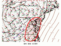
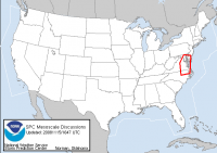
Mesoscale Discussion 2389
Nws Storm Prediction Center Norman Ok
1007 Am Cst Sat Nov 15 2008
Areas Affected...va...de...nc
Concerning...severe Potential...watch Likely
Valid 151607z - 151700z
Large Scale Forcing Is Gradually Spreading Across The Cntrl
Appalachians With Leading Edge Of Primary Ascent Now Identified By
Shallow Line Of Convection From Augusta County Va...swwd Into
Caldwell County Nc. This Activity Should Gradually Increase In Both
Depth And Intensity As Updrafts Encounter Slightly Higher Buoyancy
And Considerably Greater Low Level Moisture...sfc Dew Points In The
Mid 60s. Although Instability Will Remain Somewhat Marginal Across
The Middle Atlantic...large Scale Kinematic Fields Certainly Support
Storm Rotation And Organization. Isolated Tornadoes Are Possible
But The Primary Severe Threat Will Be Damaging Winds In Association
With Forced Squall Line. With Time Severe Threat Will Spread Into
Sern Pa And Nrn Nj And This Area Will Be Addressed Accordingly.
Tornado Watch Will Likely Be Required By 18z.
")


 ....dog is drugged......
