Wacky Weather

Smowlover409

New Member
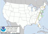
Strong Thunderstorms to effect Southern Maryland....

HAZARDOUS WEATHER OUTLOOK
NATIONAL WEATHER SERVICE BALTIMORE MD/WASHINGTON DC
1026 AM EST FRI NOV 14 2008

ANZ530>537-DCZ001-MDZ006-007-011-013-014-016>018-VAZ052>057-
151000-
CHESAPEAKE BAY NORTH OF POOLES ISLAND MD-
CHESAPEAKE BAY FROM POOLES ISLAND TO SANDY POINT MD-
CHESAPEAKE BAY FROM SANDY POINT TO NORTH BEACH MD-
CHESAPEAKE BAY FROM NORTH BEACH TO DRUM POINT MD-
CHESAPEAKE BAY FROM DRUM POINT MD TO SMITH POINT VA-
TIDAL POTOMAC FROM KEY BRIDGE TO INDIAN HEAD MD-
TIDAL POTOMAC FROM INDIAN HEAD TO COBB ISLAND MD-
TIDAL POTOMAC FROM COBB ISLAND MD TO SMITH POINT VA-
DISTRICT OF COLUMBIA-NORTHERN BALTIMORE-HARFORD-
SOUTHERN BALTIMORE-PRINCE GEORGES-ANNE ARUNDEL-CHARLES-ST. MARYS-
CALVERT-PRINCE WILLIAM/MANASSAS/MANASSAS PARK-FAIRFAX-
ARLINGTON/FALLS CHURCH/ALEXANDRIA-STAFFORD-SPOTSYLVANIA-
KING GEORGE-
1026 AM EST FRI NOV 14 2008

THIS HAZARDOUS WEATHER OUTLOOK IS FOR THE MARYLAND PORTION OF THE
CHESAPEAKE BAY...TIDAL POTOMAC RIVER...AND ADJACENT COUNTIES IN
CENTRAL MARYLAND AND NORTHERN VIRGINIA AS WELL AS THE DISTRICT OF
COLUMBIA.

.DAY ONE...TODAY AND TONIGHT

A SMALL CRAFT ADVISORY IS IN EFFECT FOR ALL WATERS AFTER MIDNIGHT.

.DAYS TWO THROUGH SEVEN...SATURDAY THROUGH THURSDAY

A SHARP COLD FRONT WILL MOVE THROUGH THE AREA ON SATURDAY.
WIDESPREAD SHOWERS AND SCATTERED THUNDERSTORMS ARE EXPECTED. A FEW
THUNDERSTORMS WILL BE CAPABLE OF PRODUCING DAMAGING WIND GUSTS.
GALE CONDITIONS ARE POSSIBLE ON SATURDAY ACROSS THE LOWER
CHESAPEAKE BAY AND LOWER POTOMAC RIVER. SMALL CRAFT ADVISORY IS
IN EFFECT FROM LATE FRIDAY NIGHT THROUGH SUNDAY AFTERNOON. SMALL
CRAFT CONDITIONS WILL BE POSSIBLE AGAIN DURING THE FIRST OF NEXT
WEEK.

.SPOTTER INFORMATION STATEMENT...

SPOTTER ACTIVATION WILL NOT BE NEEDED THROUGH TONIGHT.
HOWEVER...IT MAY BE REQUIRED ON SATURDAY.
 

Smowlover409

New Member
I'm in Ocean City right now... its like the calm before the storm, the water outback is just smooth as silk....... The weather just came on WBOC 16 and the storm system is moving fast up this way, about to leave to go to the outlets in Rehobeth, hope I get back before it gets bad! :whistle:
 

Smowlover409

New Member
Day 2 Convective Outlook
Nws Storm Prediction Center Norman Ok
0100 Am Cst Fri Nov 14 2008

Valid 151200z - 161200z

...there Is A Slgt Risk Of Svr Tstms Portions Carolinas To
Mid-atlantic Region
...

...synopsis...
Highly Amplified Upper Air Pattern Fcst This Period...related To
Strengthening And Ewd/sewd Net Motion Of Synoptic-scale Troughing
Now Evident Over N-central Conus And Central Canada. By
15/12z...cyclonic Flow Around This Trough Will Extend From N-central
High Plains Across Lower Ms Valley To Mid/upper Oh
Valley...including 110-140 Kt 250 Mb Jet. Regime Aloft Then Will
Shift Ewd Through Period...with 140-150 Kt Upper Jet Developing In
Front Of Trough...over Srn/central Appalachians...by 16/00z. Trough
Is Fcst To Move Ewd To Sern Ont...md...and Central/srn Carolinas.

At Sfc...cold Front -- Now Analyzed From Ern Ls Swwd Across Nrn
Mo...nern Ok...wrn Tx Panhandle -- Is Fcst To Surge Sewd Into Wrn
Gulf Of Mexico Day-1 And Ewd Across Ms Valley. During Daylight
Hours..expect Cold Front To Move From Central/srn Appalachians Ewd
To Mid-atlantic Coastal Plain...across Most Of Carolinas...and
Offshore Ga.

...carolinas To Mid-atlantic Region...
Scattered Tstms Are Expected To Develop -- Primarily In Linear Modes
-- Along/ahead Of Sfc Cold Front Across This Region...beginning
Early In Period And Continuing Throughout Morning/afternoon Prior To
Fropa. Main Threat Will Be Damaging Wind...with Fcst Low-level
Shear Profiles Indicating Potential For Either Supercellular Or Qlcs
Related Tornadoes In A Few Locales As Well
. Svr Probabilities
Therefore Are Being Upgraded To Categorical Criteria. Relatively
Dense Concentration Of Convective Wind Events...in Particular...is
Possible Within Broader Area Of Categorical Slgt Risk Now
Drawn...and Upgrade To Probabilities Within This Area May Be Needed
In Future Outlooks Once Mesoscale Uncertainties Are Better Resolved.


Prefrontal Air Mass Is Fcst To Destabilize Favorably Throughout
Daylight Hours...offsetting Weak Lapse Rates Enough To Remove Cinh
And To Yield Deeply But Narrowly Buoyant Thermodynamic
Profiles...with Mlcapes 500-1000 J/kg In Most Areas. Very Stg
Mid-upper Winds Will Aid Deep-layer Shear...with Fcst Soundings
Suggesting 55-70 Kt Effective Shear Magnitudes. 50-60 Kt Llj Also
Will Enhance Low Level Hodographs...yielding Favorable Low Level
Shear Profiles For Organized Bow Echoes...as Well As For Any
Relatively Discrete Storms To Rotate. Although Vertical Shear Will
Remain Favorable Farther N...svr Potential Will Become More
Conditional With Nwd Extent From Chesapeake Bay Region Up De River
Valley...
due To More Uncertainty About Sufficiency Of Diurnal
Destabilization.

Svr Potential Also Will Be Lower And More Conditional Swd Toward Nrn
Fl. Convergence Should Be Weaker With Swwd Extent Toward Gulf
Coast...with Prefrontal Winds Containing Progressively Larger Wly
Component.
 

Attachments

  • day2otlk_0700.gif
    day2otlk_0700.gif
    16.6 KB · Views: 61

Dukesdad

Well-Known Member
Day 2 Convective Outlook
Nws Storm Prediction Center Norman Ok
0100 Am Cst Fri Nov 14 2008

Valid 151200z - 161200z

...there Is A Slgt Risk Of Svr Tstms Portions Carolinas To
Mid-atlantic Region
...

...synopsis...
Highly Amplified Upper Air Pattern Fcst This Period...related To
Strengthening And Ewd/sewd Net Motion Of Synoptic-scale Troughing
Now Evident Over N-central Conus And Central Canada. By
15/12z...cyclonic Flow Around This Trough Will Extend From N-central
High Plains Across Lower Ms Valley To Mid/upper Oh
Valley...including 110-140 Kt 250 Mb Jet. Regime Aloft Then Will
Shift Ewd Through Period...with 140-150 Kt Upper Jet Developing In
Front Of Trough...over Srn/central Appalachians...by 16/00z. Trough
Is Fcst To Move Ewd To Sern Ont...md...and Central/srn Carolinas.

At Sfc...cold Front -- Now Analyzed From Ern Ls Swwd Across Nrn
Mo...nern Ok...wrn Tx Panhandle -- Is Fcst To Surge Sewd Into Wrn
Gulf Of Mexico Day-1 And Ewd Across Ms Valley. During Daylight
Hours..expect Cold Front To Move From Central/srn Appalachians Ewd
To Mid-atlantic Coastal Plain...across Most Of Carolinas...and
Offshore Ga.

...carolinas To Mid-atlantic Region...
Scattered Tstms Are Expected To Develop -- Primarily In Linear Modes
-- Along/ahead Of Sfc Cold Front Across This Region...beginning
Early In Period And Continuing Throughout Morning/afternoon Prior To
Fropa. Main Threat Will Be Damaging Wind...with Fcst Low-level
Shear Profiles Indicating Potential For Either Supercellular Or Qlcs
Related Tornadoes In A Few Locales As Well
. Svr Probabilities
Therefore Are Being Upgraded To Categorical Criteria. Relatively
Dense Concentration Of Convective Wind Events...in Particular...is
Possible Within Broader Area Of Categorical Slgt Risk Now
Drawn...and Upgrade To Probabilities Within This Area May Be Needed
In Future Outlooks Once Mesoscale Uncertainties Are Better Resolved.


Prefrontal Air Mass Is Fcst To Destabilize Favorably Throughout
Daylight Hours...offsetting Weak Lapse Rates Enough To Remove Cinh
And To Yield Deeply But Narrowly Buoyant Thermodynamic
Profiles...with Mlcapes 500-1000 J/kg In Most Areas. Very Stg
Mid-upper Winds Will Aid Deep-layer Shear...with Fcst Soundings
Suggesting 55-70 Kt Effective Shear Magnitudes. 50-60 Kt Llj Also
Will Enhance Low Level Hodographs...yielding Favorable Low Level
Shear Profiles For Organized Bow Echoes...as Well As For Any
Relatively Discrete Storms To Rotate. Although Vertical Shear Will
Remain Favorable Farther N...svr Potential Will Become More
Conditional With Nwd Extent From Chesapeake Bay Region Up De River
Valley...
due To More Uncertainty About Sufficiency Of Diurnal
Destabilization.

Svr Potential Also Will Be Lower And More Conditional Swd Toward Nrn
Fl. Convergence Should Be Weaker With Swwd Extent Toward Gulf
Coast...with Prefrontal Winds Containing Progressively Larger Wly
Component.

so when you boil this down, the wind is going to blow and the rain is going to fall right?
 

Smowlover409

New Member
Here is what they are calling for on the Eastern Shore :cds:

HAZARDOUS WEATHER OUTLOOK
NATIONAL WEATHER SERVICE WAKEFIELD VA
354 PM EST FRI NOV 14 2008

MDZ021>025-VAZ048-049-060>086-088>091-094-099-100-152100-
DORCHESTER-WICOMICO-SOMERSET-INLAND WORCESTER-MARYLAND BEACHES-
FLUVANNA-LOUISA-PRINCE EDWARD-CUMBERLAND-GOOCHLAND-HANOVER-CAROLINE-
MECKLENBURG-LUNENBURG-NOTTOWAY-AMELIA-POWHATAN-CHESTERFIELD-HENRICO-
KING WILLIAM-KING AND QUEEN-ESSEX-WESTMORELAND-RICHMOND-
NORTHUMBERLAND-LANCASTER-BRUNSWICK-DINWIDDIE-PRINCE GEORGE-
CHARLES CITY-NEW KENT-GLOUCESTER-MIDDLESEX-MATHEWS-SUSSEX-SURRY-
JAMES CITY-YORK-NEWPORT NEWS/HAMPTON-ACCOMACK-NORTHAMPTON VA-
354 PM EST FRI NOV 14 2008

THIS HAZARDOUS WEATHER OUTLOOK IS FOR THE LOWER EASTERN SHORE OF
MARYLAND...CENTRAL VIRGINIA...EAST CENTRAL VIRGINIA...INTERIOR
SOUTHEAST VIRGINIA...SOUTH CENTRAL VIRGINIA...THE EASTERN SHORE OF
VIRGINIA...THE MIDDLE PENINSULA OF VIRGINIA...THE NORTHERN NECK OF
VIRGINIA...THE PENINSULA OF SOUTHEAST VIRGINIA AND THE PIEDMONT OF
CENTRAL VIRGINIA.

.DAY ONE...THIS AFTERNOON AND TONIGHT.

PERIODS OF RAIN SHOWERS WILL CONTINUE THROUGH TONIGHT...AND
POSSIBLY DEVELOP SCATTERED THUNDERSTORMS ACROSS THE AREA...MAINLY
AFTER MIDNIGHT. SOME OF THESE THUNDERSTORMS MAY BECOME SEVERE AND
HAVE THE ABILITY TO PRODUCE DAMAGING WINDS...VERY HEAVY
RAINFALL...AND POSSIBLY AN ISOLATED TORNADO.


.DAYS TWO THROUGH SEVEN...SATURDAY THROUGH THURSDAY.

SCATTERED THUNDERSTORMS WILL CONTINUE THROUGH EARLY SATURDAY
AFTERNOON. SOME OF THESE THUNDERSTORMS MAY BECOME
SEVERE AND HAVE THE ABILITY TO PRODUCE DAMAGING WINDS...VERY HEAVY
RAINFALL...AND POSSIBLY AN ISOLATED TORNADO.

.SPOTTER INFORMATION STATEMENT...

SPOTTER ACTIVATION MAY BE NEEDED.

$$
 

Dukesdad

Well-Known Member
Oh. PS , I just have a bunch of new ammo I am eager to try out.:killingme

Have a blast. I hear the sea run are in and being caught near Pt Lookout.

I know you are trying to say you will blast away at me in the morning but did i tell you I bought a new AR? WE can shoot out back anytime you want.
 
Top