Southern Maryland Railroad

nhboy

Ubi bene ibi patria
LocoEngineer said:
I am originally from the Pittsburgh area which has numerous railroads in the area. Since moving to Southern Maryland in 1987, I have been curious about the railroad that once extended to NAS Patuxent River.

A friend of mine who has lived in the area for a long time told me about some of the artifacts from the railroad that were still around. I took some photos of our discoveries. They are posted at http://www.geocities.com/ken72465/SMRR.htm

I am interested in finding photos of some of the trains in various locations along the line. I have already inquired at the library in Leonardtown and only found some references of a few paragraphs.

Thanks,

-Ken

Have you seen this?

BTW, Great photos, especially the USN site. I've bookmarked your site.
 
Last edited:

SLIM

Active Member
sowhat said:
Check out the Laural Grove Sub Shop (in front of the ball park there) He's got some information about the SoMd railroad and pictures on the walls.
:yeahthat:
'The place' used to be a train stop, I don't know when, but that is what I was told. Then it became "235 DINER" for YEARS. My grandmother used to own the business until the late 70's. I remember sometime in the 60's the train would still stop by the place and my older brother would hop on and ride it to our house in Oakville then catch them on the return trip on the way back. Mr. Leland used to own the building. I haven't been to the Sub Shop in awhile but they had some pictures in there that some of the people from the neighborhood gave to them from way back when it was a station!
:smile:
 

Tomcat

Anytime
Aa3rt said:
Does anyone recognize the building in the background?
Possibly the old building roughly at the corner of Chaptico / Mechanicsville Rd. and Old Rt. 5. Behind the Mechanicsville Fire Dept?
 

SLIM

Active Member
Tomcat said:
Possibly the old building roughly at the corner of Chaptico / Mechanicsville Rd. and Old Rt. 5. Behind the Mechanicsville Fire Dept?
It could be that but it looks like 'Halfway House' to me. That's where WAWA is now.
 
Last edited:

Tomcat

Anytime
SLIM said:
It could be that but it looks lik the old 'Halfway House' to me. That's where WAWA is now.
The old railroad tracks didn't go past the Half Way House. They crossed Rt. 5 about a mile down the road towards Leonardtown.
 

SLIM

Active Member
:confused:
Tomcat said:
The old railroad tracks didn't go past the Half Way House. They crossed Rt. 5 about a mile down the road towards Leonardtown.
:howdy:
Then where did they go after that to be able to run right behind 235 Diner?
 

Pullman

New Member
Aa3rt,

I'm trying to track down images of the Navy Railroad that served Pax-River between 1945 and 1954. More specifically we are very interested in locating any image B&W or Color of the Caboose.
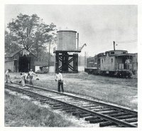
Ex-N&W CF Caboose (US Navy)(s).jpg
Above image is of the Caboose near the Wye in the tracks near Bowie MD.

The former N&W Caboose "who joined the Navy". Our goals are multi faceted, first we want to gain more knowledge of what happened to the caboose after it joined the Navy...How was it lettered? What number/s did it carry? how was it panted? (Some of which we can sort of see in the one image we already have from a magazine article) Another facet is that this knowledge will join our files in the Norfolk & Western Historical Society Archives (NWHS) as we attempt to broaden our understanding as to what happened to the Cabooses that left the Norfolk & Western for second or more lives after service on the railroad of their birth. We have had success in following and researching many of the cabooses that left the N&W but the "Navy" caboose has proved to be very elusive. With your help our goal is to connect with you or an individual or group that may have images of this particular caboose that will help us answer some of our questions and help us better understand what the caboose that joined the Navy looked like while it was in service. What we do know is the following:

-Norfolk & Western Railway Caboose 518104 was built new in 8-1915 and then later Sold by the Norfolk & Western Railway in 9-1945 to US Navy Bureau of Aeronautics, our belief/understanding is that this caboose was used by the Navy at it's railroad serving the Naval Air Station Patuxent River from late 1945 till 1954 at which time the Navy stopped operations of it's railroad on to the base and later removed the rail line. We do not know what happened to the caboose after 1954? Was it sold? Was it scrapped? Was it transferred to another Naval operation? As mentioned above, what did the caboose look like over the nine (9) years that it served in the Navy? This is why we desire image to support our interest, photographic evidence of what it looked like.

We know someone has to have images snapped by a father/mother, grand father, service member, relative or someone who took interest in the Navy's railroad serving the Naval Base. Given how public the grade crossings were and the communities that it passed through or served and the customers involved along the way someone must have taken pictures somewhere of it over the nine (9) years in service or after it left for yet another life beyond Pax River. Our goal with you is to make contact with someone who knows they have an old album of images or knows of someone who has an album of images of the Navy Rail Road that serviced Pax-River and was part of the community and so many for nine years plus. While the article in the story reference the images as being "US Navy Images" no files of railroad images have been located via the Navy up to this point.

I have already worked with the Museum out side the main gate at Pax-River. The Base library, the Base historians, the base archaeologist, the state (Maryland) office of historical records in Department of Transportation, the Naval Archives, the National Archives, The St Mary's Historical Society, and the Enterprise News Paper, among many other groups and individuals. I'd love to make contact with Paul Rogers as well if he is still around. But between you and Paul, you are my best chances for locating information to help us in our research of this caboose that was bought and used on the "Navy's Railroad".

Any help you can provide would be welcome and greatly appreciated. As a side note I believe the Local News Paper the "Enterprise" will be running an article requesting help on images to support our research efforts very soon too.

Hope this message finds you well and I look forward to hearing back from you.

Steve Smith
Roanoke VA
(540) 312-6011
 

officeguy

Well-Known Member
What is remarkable about the SMR is the fact that in 1868 someone had the foresight to plan a railroad into southern maryland from DC rather than centering it on Baltimore. Had the SMR succeeded rather than the harebrained Baltimore and Potomac (now Pope creek subdivision of CSX) scheme, we would now have a railroad ROW connecting SoMD to DC. A couple of years ago, someone did a study on expanding MARC on the CSX track, with the long loop all the way to Bowie, it made no sense as it offered very little potential for time savings. A ROW along the proposed alignment of the original SMR would have made such a project feasible.
 

So_what

Yes I'm an MPD, But who's
:confused:
:howdy:
Then where did they go after that to be able to run right behind 235 Diner?

Look on google maps using earth view, zoom in enough and you can find Three Notch Trail, that's the bike path through Mechanicsville. That's the old railroad right of way. It pretty much paralells Rt.5 down to the Mechanicsville Elementary School then veers westerly. Then just before crossing Rt5 about a mile down from the old Halfway House it makes about a 90 degree bend back towards Rt.235. You can follow the trail just about all the way to gate 1 of the Base where it crossed Rt.235 into the base.
 

So_what

Yes I'm an MPD, But who's
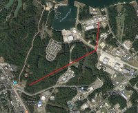
Here is where the rr ran on the base. Roughly from what is now gate 1 to the fuel farm and down to supply.
Navy RR 2.jpg
 

3CATSAILOR

Well-Known Member
I am originally from the Pittsburgh area which has numerous railroads in the area. Since moving to Southern Maryland in 1987, I have been curious about the railroad that once extended to NAS Patuxent River.

A friend of mine who has lived in the area for a long time told me about some of the artifacts from the railroad that were still around. I took some photos of our discoveries. They are posted at http://www.geocities.com/ken72465/SMRR.htm

I am interested in finding photos of some of the trains in various locations along the line. I have already inquired at the library in Leonardtown and only found some references of a few paragraphs.

Thanks,

-Ken

NAS Pax still has train tracks in the Supply Dept section of the base. I guess the trains came through their in the 40s/50s? Don't know.
 

SandieGarry

Active Member
I may be wrong in some of this but if I remember correctly, 235 was 1 lane N and S from just north of Laurel Grove Park. When the state decided to widen the road, they used the railroad right of way. That's why the Three Notch trail from Laurel Grove south is sort of in limbo, there is no right of way to claim. The power lines from Laurel Grove south do not follow the railroad bed as some people think. The old railroad is actually the southbound lanes of rt 235 from Laurel Grove to some point unknown to me. I remember as a kid in the late 60's early 70's watching the train go up and down the tracks.

Please correct me if my memory is wrong.
 
Top