Tropical Storm Hermine

Gilligan

#*! boat!
PREMO Member
who has bread, milk and TP?

mmm...the best part about hurricanes: Milk sammiches.

We're almost done with our prepping: 4 5-gallon jugs of gas for the generators to keep the fridges cold, and 6 cases of beer to go in those fridges.

Done.
 

PeoplesElbow

Well-Known Member
My 12 year old comment that something called Hermine can't be very bad. I reminded him that Hurricane Irene was the one that took out two cars and part of our detached garage so don't judge based on the name.

My grandmothers name was Irene, she was hell on wheels.
 

Chris0nllyn

Well-Known Member
2pm model shows a similar path and it strengthening back into a hurricane off the coast of Ocean City (far out).

The warnings and watched posted early still hold true with the edge of 72 hour cone of uncertainty still smack in the middle of the bay.

http://www.nhc.noaa.gov/refresh/graphics_at4+shtml/153527.shtml?5-daynl#contents

NWS's latest advisory:
NEW INFORMATION
---------------

* CHANGES TO WATCHES AND WARNINGS:
- A TROPICAL STORM WARNING HAS BEEN ISSUED FOR ST. MARYS

* CURRENT WATCHES AND WARNINGS:
- A TROPICAL STORM WARNING IS IN EFFECT FOR ST. MARYS

* STORM INFORMATION:
- ABOUT 500 MILES SOUTH-SOUTHWEST OF WASHINGTON DC OR ABOUT 540
MILES SOUTH-SOUTHWEST OF BALTIMORE MD
- 32.5N 81.3W
- STORM INTENSITY 50 MPH
- MOVEMENT NORTHEAST OR 45 DEGREES AT 18 MPH

SITUATION OVERVIEW
------------------

TROPICAL STORM HERMINE LOCATED OVER SOUTHEASTERN GEORGIA WILL MOVE
NORTHEAST DURING THE NEXT 48 HOURS MAKING ITS CLOSEST APPROACH TO ST MARYS
COUNTY SATURDAY AFTERNOON. RAINBANDS AND WINDS TO TROPICAL STORM FORCE
WILL BEGIN TO AFFECT SOUTHERN MARYLAND LATE TONIGHT OR EARLY SATURDAY
AND CONTINUE INTO SUNDAY MORNING. HERMINE WILL THEN SLOW DOWN
SIGNIFICANTLY OR POSSIBLY STALL OUT OFF THE MID ATLANTIC COAST SUNDAY.
THE STORM MAY MOVE BACK TOWARD THE COAST SUNDAY OR MONDAY POSSIBLY BRINGING
MORE RAIN AND WIND FARTHER INLAND...BUT THIS PART OF THE FORECAST REMAINS
MORE UNCERTAIN.
http://forecast.weather.gov/wwamap/wwatxtget.php?cwa=lwx&wwa=hurricane local statement
 
Last edited:

Gilligan

#*! boat!
PREMO Member
Gilligan, stgislander,

How were the tides there this morning? This afternoon?

Looking like we're going to get flooded real good. The tide was low at 9:50 this morning and was way above what would be normal high tide. At 2' 6" or thereabouts now. At 3', sections of the main road start being flooded. At 3' 6", sections of the main road become impassible in low vehicle (unless you are not real concerned about sacrificing your car). Based on what I'm seeing right now...bet we're looking at 4'. Just over a 2' surge in other words.

Of course that's a long way from the 5'5" record set by Isabell in '03.


Wind is getting pretty vicious too. From the NE with gusts above 45 right now..
 
Well, pretty sure you've got as much under control as you can, but if there is anything you need, shout. Pretty quiet here now, just some gusts in the tops of the trees.
 

Gilligan

#*! boat!
PREMO Member
Whitecapping in the creek. Be in the yard in another hour. I am somewhat encouraged by how slowly the tide is rising though. Might not be as bad as I first thought.

3 Sept storm.jpg
 
If you haven't heard, there was a 5.6 earthquake this morning centered in Pawnee, OK, also felt in the neighboring states. I just got a picture from my SIL in Arkansas showing the damage.

IMG9598071.jpg
 

Gilligan

#*! boat!
PREMO Member
Not going to be bad at all. Tide has just reached 3' and it's a little over 2 hours until high tide, so this is shaping up to be a non-event. A neighbor with a wind gauge clocked some gusts at 60 mph though..and his place is more sheltered than mine and on the same shoreline facing the same direction.

I've been meaning to get one of those fancy wifi weather stations. One of these days
 

Gilligan

#*! boat!
PREMO Member
Final update. This was nothing. Tide barely exceeded 3' (so much for my mad predicksun skillz) and the wind is dying off and clocking north as it does.

And I see patches of blue sky appearing....let the official Labor Day celebrating begin! As soon as the water recedes a bit and we can get off the island....
 
Last edited:
Reports are still calling for 10-20 mph winds thru at least Monday with up to 40 mph gusts tomorrow.

It'll be breezy, but not as bad as it could have been.
 

Popster

Member
Sorry I didn't read this sooner. Didn't expect as of yesterday that this would be a huge event. Didn't expect winds over 33 mph. Check out this site for good info.

https://www.wunderground.com/cgi-bin/findweather/getForecast?query=zmw:20670.3.99999&MR=1

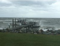
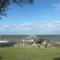
Here's a pic during the worst of it late morning and then one late afternoon. We had less that .1" of rain. I need rain for the garden.

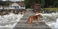
Beanie had to check out the situation.

We sacrificed some crabs to the Bay gods for dinner

Capture.JPG

Capture1.JPG

Capture3.JPG

Capture4.JPG

Hattie thought it was a walk in the park this evening

Capture5.jpg
 

littlelady

God bless the USA
Sorry I didn't read this sooner. Didn't expect as of yesterday that this would be a huge event. Didn't expect winds over 33 mph. Check out this site for good info.

https://www.wunderground.com/cgi-bin/findweather/getForecast?query=zmw:20670.3.99999&MR=1

Here's a pic during the worst of it late morning and then one late afternoon. We had less that .1" of rain. I need rain for the garden.

Beanie had to check out the situation.

We sacrificed some crabs to the Bay gods for dinner

View attachment 114612

View attachment 114613

View attachment 114614

View attachment 114615

Hattie thought it was a walk in the park this evening

View attachment 114616

Hattie and Beanie! I was having withdrawals because you haven't posted, lately. Thank goodness we didn't get much of the storm. Our house is up for sale, and the last thing we needed was for a tree to fall on it; which happened with Irene. Thank goodness this storm didn't cause damage to the area. Hope all are ok. We are having crabs on Tuesday!
 
Last edited:
Top