
You are using an out of date browser. It may not display this or other websites correctly.
You should upgrade or use an alternative browser.
You should upgrade or use an alternative browser.
Snow?
- Thread starter scotty62
- Start date
twinoaks207
Having Fun!
Alert for my area:
WINTER STORM WATCH IN EFFECT FROM TUESDAY AFTERNOON
THROUGH LATE TUESDAY NIGHT
Urgent - Winter Weather Message
National Weather Service Baltimore MD/Washington DC
403 AM EST Mon Jan 10 2011
Carroll-Northern Baltimore-Harford-Howard-Southern Baltimore-
Prince Georges-Anne Arundel-
Including The Cities Of... Westminster... Columbia... Baltimore...
Annapolis
... Winter Storm Watch In Effect From Tuesday Afternoon Through
Late Tuesday Night...
The National Weather Service In Baltimore MD/Washington Has
Issued A Winter Storm Watch... Which Is In Effect From Tuesday
Afternoon Through Late Tuesday Night.
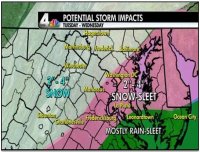
* Precipitation Type... Snow.
* Accumulations... Potential For 5 Or More Inches Of Snow.
* Timing... Snow Is Expected To Develop During The Midday Or Early
Afternoon On Tuesday... And Continue Through Tuesday Night.
* Temperatures... Highs In The Lower 30s Tuesday. Lows In The Mid
20s Tuesday Night.
* Winds... Northeast 5 To 10 Mph Tuesday... Becoming Northwest 10 To
15 Mph Tuesday Night.
Precautionary/Preparedness Actions...
A Winter Storm Watch Means There Is A Potential For Significant
Snow Accumulations That May Impact Travel. Continue To Monitor
The Latest Forecasts.
WINTER STORM WATCH IN EFFECT FROM TUESDAY AFTERNOON
THROUGH LATE TUESDAY NIGHT
Urgent - Winter Weather Message
National Weather Service Baltimore MD/Washington DC
403 AM EST Mon Jan 10 2011
Carroll-Northern Baltimore-Harford-Howard-Southern Baltimore-
Prince Georges-Anne Arundel-
Including The Cities Of... Westminster... Columbia... Baltimore...
Annapolis
... Winter Storm Watch In Effect From Tuesday Afternoon Through
Late Tuesday Night...
The National Weather Service In Baltimore MD/Washington Has
Issued A Winter Storm Watch... Which Is In Effect From Tuesday
Afternoon Through Late Tuesday Night.
* Precipitation Type... Snow.
* Accumulations... Potential For 5 Or More Inches Of Snow.
* Timing... Snow Is Expected To Develop During The Midday Or Early
Afternoon On Tuesday... And Continue Through Tuesday Night.
* Temperatures... Highs In The Lower 30s Tuesday. Lows In The Mid
20s Tuesday Night.
* Winds... Northeast 5 To 10 Mph Tuesday... Becoming Northwest 10 To
15 Mph Tuesday Night.
Precautionary/Preparedness Actions...
A Winter Storm Watch Means There Is A Potential For Significant
Snow Accumulations That May Impact Travel. Continue To Monitor
The Latest Forecasts.
awpitt
Main Streeter
Anyone know what the latest forcast is? Are we getting snow on Tuesday?
Watch the weather forcast on TV. Then check the weather Websites.
Dymphna
Loyalty, Friendship, Love
Alert for my area:
WINTER STORM WATCH IN EFFECT FROM TUESDAY AFTERNOON
THROUGH LATE TUESDAY NIGHT
Urgent - Winter Weather Message
National Weather Service Baltimore MD/Washington DC
403 AM EST Mon Jan 10 2011
Carroll-Northern Baltimore-Harford-Howard-Southern Baltimore-
Prince Georges-Anne Arundel-
Including The Cities Of... Westminster... Columbia... Baltimore...
Annapolis
... Winter Storm Watch In Effect From Tuesday Afternoon Through
Late Tuesday Night...
The National Weather Service In Baltimore MD/Washington Has
Issued A Winter Storm Watch... Which Is In Effect From Tuesday
Afternoon Through Late Tuesday Night.
* Precipitation Type... Snow.
* Accumulations... Potential For 5 Or More Inches Of Snow.
* Timing... Snow Is Expected To Develop During The Midday Or Early
Afternoon On Tuesday... And Continue Through Tuesday Night.
* Temperatures... Highs In The Lower 30s Tuesday. Lows In The Mid
20s Tuesday Night.
* Winds... Northeast 5 To 10 Mph Tuesday... Becoming Northwest 10 To
15 Mph Tuesday Night.
Precautionary/Preparedness Actions...
A Winter Storm Watch Means There Is A Potential For Significant
Snow Accumulations That May Impact Travel. Continue To Monitor
The Latest Forecasts.
Funny, my weather forecast says the same things...with a couple of exceptions...
CHARLES-ST. MARYS-CALVERT-
INCLUDING THE CITIES OF...WALDORF...ST MARYS CITY
403 AM EST MON JAN 10 2011
...WINTER STORM WATCH IN EFFECT FROM TUESDAY MORNING THROUGH LATE
TUESDAY NIGHT...
TIMING...SNOW IS EXPECTED TO DEVELOP DURING THE MID TO LATE
MORNING TUESDAY...AND CONTINUE THROUGH TUESDAY NIGHT. SLEET MAY
MIX WITH SNOW TUESDAY AFTERNOON AND EVENING.
awpitt
Main Streeter
Issued by The National Weather Service
Baltimore/Washington, MD
4:03 am EST, Mon., Jan. 10, 2011
... WINTER STORM WATCH IN EFFECT FROM TUESDAY MORNING THROUGH LATE TUESDAY NIGHT...
THE NATIONAL WEATHER SERVICE IN BALTIMORE MD/WASHINGTON HAS ISSUED A WINTER STORM WATCH... WHICH IS IN EFFECT FROM TUESDAY MORNING THROUGH LATE TUESDAY NIGHT.
* PRECIPITATION TYPE... SNOW AND SLEET.
* ACCUMULATIONS... POTENTIAL FOR 5 OR MORE INCHES OF SNOW AND SLEET.
* TIMING... SNOW IS EXPECTED TO DEVELOP DURING THE MID TO LATE MORNING TUESDAY... AND CONTINUE THROUGH TUESDAY NIGHT. SLEET MAY MIX WITH SNOW TUESDAY AFTERNOON AND EVENING.
* TEMPERATURES... HIGHS IN THE LOWER TO MID 30S TUESDAY. LOWS IN THE MID TO UPPER 20S TUESDAY NIGHT.
* WINDS... NORTHEAST 5 TO 10 MPH TUESDAY... BECOMING NORTHWEST 10 TO 15 MPH TUESDAY NIGHT.
PRECAUTIONARY/PREPAREDNESS ACTIONS...
A WINTER STORM WATCH MEANS THERE IS A POTENTIAL FOR SIGNIFICANT SNOW AND SLEET ACCUMULATIONS THAT MAY IMPACT TRAVEL. CONTINUE TO MONITOR THE LATEST FORECASTS.
awpitt
Main Streeter
This morning forecast says snow/sleet/rain mix Tue afternoon, would not be surprised if the youngins get out of school early.
Out of school early? Heck, they'll just close schools altogether because of the possibility of snow.
2Bullies73
New Member
Dagger
Supposed to go to the Wizards game that night... ugh!!
Supposed to go to the Wizards game that night... ugh!!
chernmax
NOT Politically Correct!!
Out of school early? Heck, they'll just close schools altogether because of the possibility of snow.
With the 7-8 accidents after the last snow just down here, that may be a good thing! I heard this morning 4-6 inches in our area on Fox 5 news
awpitt
Main Streeter
With the 7-8 accidents after the last snow just down here, that may be a good thing! I heard this morning 4-6 inches in our area on Fox 5 news
I saw that on Fox 5 as well but it all depends on what actually happens.
From WJLA...
A WINTER STORM WATCHis in effect from Tuesday afternoon until Tuesday night for areas east of the city including Prince Georges, Anne Arundel, Charles, Calvert, and St Marys Counties. A watch is issues in advance of a storm when there is potential for significant snow. But while areas east of town should get the bulk of the snow, there is a possibility of a mix, therefore amounts could be lowered and the watch could be downgraded. Stay tuned….
chernmax
NOT Politically Correct!!
I saw that on Fox 5 as well but it all depends on what actually happens.
From WJLA...
A WINTER STORM WATCHis in effect from Tuesday afternoon until Tuesday night for areas east of the city including Prince Georges, Anne Arundel, Charles, Calvert, and St Marys Counties. A watch is issues in advance of a storm when there is potential for significant snow. But while areas east of town should get the bulk of the snow, there is a possibility of a mix, therefore amounts could be lowered and the watch could be downgraded. Stay tuned….
Yes but the potential mix is sleet as a result of the low temperatures which can make driving conditions much worse than just the accumulation of snow!

ArkRescue
Adopt me please !


We want smow ...


Looks like St. Mary's is under the less snow to a mix zone. I wouldn't be surprised if our Winter Storm Watch get downgraded to a winter weather advisory by this evening.
mmesser0
C-A-P-S CAPS CAPS CAPS!
Supposed to go to the Wizards game that night... ugh!!
just stay home and watch it... you're not missing much.

ArkRescue
Adopt me please !

ArkRescue
Adopt me please !
If I had extra time to contemplate the universe according to Lance, I would, but I just don't have that kind of time to invest in speculation that may just prove what others here already know ...... in the meantime we spend as much time laughing at Lance as he does at us  and last I heard laughing was good for us?
and last I heard laughing was good for us?snow, like frozen precip. must b yr lingo. only 25 letters in yr alphabet???
btw how come yr fons` busted?
Toxick
Splat
snow, like frozen precip. must b yr lingo. only 25 letters in yr alphabet???
btw how come yr fons` busted?
snow or smow, w/ev its all the same as long as u can slide, or tk ur snowbunny inside 2 the frnt of the fire 2 get ur gruv on! It is whut it is! FTW!