You are using an out of date browser. It may not display this or other websites correctly.
You should upgrade or use an alternative browser.
You should upgrade or use an alternative browser.
Hurricane
- Thread starter vraiblonde
- Start date
Yeah, Louis L'Amour.Maybe it was a really good book....

Well heck yeah!....I'd sit through a nuclear strike if I had my hands on a Louis L'Amour book I had not yet read.Yeah, Louis L'Amour.
Guess there is no future for us, eh?
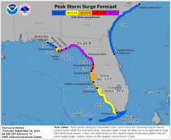
The big issue will be the storm surge more than wind, but looks like surge in your area is going to be pretty low. Should be able to ride this one out ok.
View attachment 179664
Yeah, it's just going to be annoying rain. But it's creepy here because everyone else is gone, baby, gone. Me and my neighbor up the street are the only ones who've stayed.
And now a hundred illegal alien squatters will move in.Yeah, it's just going to be annoying rain. But it's creepy here because everyone else is gone, baby, gone. Me and my neighbor up the street are the only ones who've stayed.
frequentflier
happy to be living
OpportunistsAnd now a hundred illegal alien squatters will move in.
LightRoasted
If I may ...
For your consideration ...
This is personally intriguing. For the longest time, (which means forever), and I don't really know why, but I have always thought, assumed, that Florida's panhandle area, the northern boundary line for Florida, was a straight line east to west, just like Maryland's Mason Dixon Line. Even though I have seen and looked at Florida on maps, and driving routes over my lifetime, too many times to remember, and even visiting the state and seeing nearly every rest stop map, I never noticed that it isn't a straight flat line, but instead is in fact not straight. Even drove to Destin via I-10 from Jacksonville a couple of years ago, seeing Florida maps at stops. (Many of which were posted everywhere complements of Florida's toll system). It never clicked in my head.
Just an interesting personal insight observation I thought I share. I know there is a term for this, just can't remember it.
A map so when the weather people say "Big Bend" or "Panhandle" you'll know what they're talking about:
View attachment 179632
This is personally intriguing. For the longest time, (which means forever), and I don't really know why, but I have always thought, assumed, that Florida's panhandle area, the northern boundary line for Florida, was a straight line east to west, just like Maryland's Mason Dixon Line. Even though I have seen and looked at Florida on maps, and driving routes over my lifetime, too many times to remember, and even visiting the state and seeing nearly every rest stop map, I never noticed that it isn't a straight flat line, but instead is in fact not straight. Even drove to Destin via I-10 from Jacksonville a couple of years ago, seeing Florida maps at stops. (Many of which were posted everywhere complements of Florida's toll system). It never clicked in my head.
Just an interesting personal insight observation I thought I share. I know there is a term for this, just can't remember it.
Yeah, it's just going to be annoying rain. But it's creepy here because everyone else is gone, baby, gone. Me and my neighbor up the street are the only ones who've stayed.
Thank goodness fer dat."Nobody said nuthin about pants!"
"Nobody said nuthin about pants!"
They only film from the waist up.
That sounds like an Anderson Cooper question.If you are waste deep in water, do you really need pants?
@vraiblonde How are you making out?
@vraiblonde How are you making out?
It's raining, it's pouring, I've spent the day in the recliner snoring....
Gretel has cabin fever and is driving me batshit

Take her for a walk and move all the porch pineapples to other homes.Gretel has cabin fever and is driving me batshit
What Ken said!It's raining, it's pouring, I've spent the day in the recliner snoring....
Gretel has cabin fever and is driving me batshit
X100What Ken said!

Now upgraded to a Cat 4. Going to be a rough ride.
Yeah, I feel for those folks - they get it almost every time.

