cattitude
My Sweetest Boy
What's wrong with this post?
Ugh...

What's wrong with this post?
Just read this from National Weather Service
Winter Storm Watch
St. Marys (Maryland)
URGENT - WINTER WEATHER MESSAGE
NATIONAL WEATHER SERVICE BALTIMORE MD/WASHINGTON DC
750 AM EST FRI JAN 29 2010
MDZ017-VAZ036-037-050-056-057-292100-
/O.CON.KLWX.WS.A.0003.100130T0500Z-100131T0500Z/
ST. MARYS-NELSON-ALBEMARLE-ORANGE-SPOTSYLVANIA-KING GEORGE-
INCLUDING THE CITIES OF...ST MARYS CITY...CHARLOTTESVILLE...
FREDERICKSBURG
750 AM EST FRI JAN 29 2010
...WINTER STORM WATCH REMAINS IN EFFECT FROM LATE TONIGHT THROUGH
SATURDAY EVENING...
A WINTER STORM WATCH REMAINS IN EFFECT FROM LATE TONIGHT THROUGH
SATURDAY EVENING.
* PRECIPITATION TYPE...SNOW.
* ACCUMULATIONS...POTENTIAL FOR 5 OR MORE INCHES.
* TIMING...12 AM SATURDAY THROUGH 12 AM SUNDAY.
* TEMPERATURES...LOW TO MID 20S THROUGH SATURDAY. TEMPERATURES
WILL DROP INTO THE TEENS SATURDAY EVENING.
* WINDS...NORTH-NORTHEAST AT 5 TO 10 MPH.
PRECAUTIONARY/PREPAREDNESS ACTIONS...
A WINTER STORM WATCH MEANS THERE IS A POTENTIAL FOR SIGNIFICANT
SNOW ACCUMULATIONS THAT MAY IMPACT TRAVEL. CONTINUE TO MONITOR
THE LATEST FORECASTS.
Yep... here is the forecast for mid-day Saturday. Forecast Maps : Weather Underground
St. Mary's City?

St. Mary's City?
Yes.
This is one of those cases when the southern part of St. Mary's County will get more than the northern part.
Sounds about right.
Either way, it's gonna be COLD!
Yes.
This is one of those cases when the southern part of St. Mary's County will get more than the northern part.
Just one the many cities in SoMD.
*Note to self: Beer run
Actually the report is for MDZ017, which is the entire county as related to KNHK (Pax River).Yes, I know that. I posted that because the person that posted that seemed to think (maybe) that that weather report was for most of St. Mary's County when, in fact, it really only addressed St. Mary's City and counties of Virginia. I know where St. Mary's City is located. Sheesh.
... WINTER WEATHER ADVISORY IN EFFECT FROM 7 AM SATURDAY TO 4 AM EST SUNDAY...
THE NATIONAL WEATHER SERVICE IN STERLING VIRGINIA HAS ISSUED A WINTER WEATHER ADVISORY FOR SNOW... WHICH IS IN EFFECT FROM 7 AM SATURDAY TO 4 AM EST SUNDAY. THE WINTER STORM WATCH IS NO LONGER IN EFFECT.
* PRECIPITATION TYPE... SNOW.
* ACCUMULATIONS... 3 TO 5 INCHES.
* TIMING... SNOW WILL BEGIN SATURDAY MORNING AND IT WILL PERSIST THROUGH THE OVERNIGHT HOURS. SNOW WILL BE HEAVIEST SATURDAY AFTERNOON AND EVENING.
* TEMPERATURES... TEMPERATURES AROUND 20 SATURDAY MORNING WILL RISE INTO THE MID 20S SATURDAY AFTERNOON.
* WINDS... NORTHEAST AT 5 TO 10 MPH.
PRECAUTIONARY/PREPAREDNESS ACTIONS...
A WINTER WEATHER ADVISORY MEANS THAT PERIODS OF SNOW WILL CAUSE TRAVEL DIFFICULTIES. BE PREPARED FOR SLIPPERY ROADS AND LIMITED VISIBILITIES... AND USE CAUTION WHILE DRIVING.
Winter storm watch cancelled. Winter weather advisory in effect for Charles and St. Mary's Counties from 7 AM Saturday morning to 4 AM Sunday Morning
Based on the latest models the range for snowfall totals in St Mary's county is 2 inches in Charlotte Hall up to 6 inches south of Lexington Park. That is based on the NGP model.... It is updating right now and this could change... Most of the Storm will move south of St, Mary's county...
No I want more then just 2 inches of snow, I want at least 7 inches of smow.

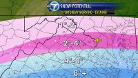
Here's WJLA's take on the snow totals......
Here's WJLA's take on the snow totals......