OldHillcrestGuy
Well-Known Member
Sorry, RIDGE is taking it!
WOW Maybe you can run multiple calls, like maybe 3 in a day instead of one a week.

Sorry, RIDGE is taking it!
WOW Maybe you can run multiple calls, like maybe 3 in a day instead of one a week.

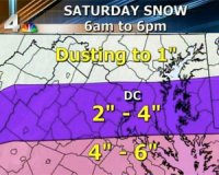
And here is nbc4.com
You should make some potato salad to go with your burgers and dogs cooked on the grill this weekend...Boo. We're in the dusting to 1" range.

You should make some potato salad to go with your burgers and dogs cooked on the grill this weekend...

Oh no you di-in't! I'm still gonna cook, I just won't be watching gently falling flakes of snow out the window while I do it.
The latest NGP model, just released, based on 12Z today (7 am here I believe) is now suggesting 2.4 inches to 4.7 inches of snow for St Mary's County depending on location... Obviously less to north and more to the south.

Quick Question:
How can Charles County be in the advisory and Calvert Not be, Calvert is directly East of Charles...right? Please explain to me. Will the snow hit Charles and as it crosses the patuxent just STOP??
Bob Ryan just said storm is looking like it might just turn a bit north. His snow graph had lower St Mary's in and 6 - 12 inch range. Northern St. Marys and Charles 4-6. We might not know how much we will be getting as far as snow, but dang its going to cold tomorrow high of 23.
...WINTER STORM WARNING IN EFFECT FROM 7 AM SATURDAY TO 4 AM EST
SUNDAY...
THE NATIONAL WEATHER SERVICE IN STERLING VIRGINIA HAS ISSUED A
WINTER STORM WARNING FOR SNOW...WHICH IS IN EFFECT FROM 7 AM
SATURDAY TO 4 AM EST SUNDAY. THE WINTER WEATHER ADVISORY IS NO
LONGER IN EFFECT.
* PRECIPITATION TYPE...SNOW.
* ACCUMULATIONS...3 TO 6 INCHES.
* TIMING...SNOW WILL BEGIN SATURDAY MORNING AND IT WILL PERSIST
PAST MIDNIGHT. SNOW WILL BE HEAVIEST SATURDAY AFTERNOON AND
EARLY EVENING.
* TEMPERATURES...TEMPERATURES IN THE LOWER 20S SATURDAY MORNING
WILL RISE INTO THE MID 20S SATURDAY AFTERNOON. TEMPERATURES
SATURDAY NIGHT WILL FALL INTO THE TEENS.
* WINDS...NORTHEAST 10 TO 15 MPH. SOME GUSTS UP TO 20 TO 25 MPH
WILL BE POSSIBLE SATURDAY AFTERNOON AND EVENING ALONG THE
SHORELINE OF THE CHESAPEAKE BAY.
PRECAUTIONARY/PREPAREDNESS ACTIONS...
A WINTER STORM WARNING MEANS SIGNIFICANT AMOUNTS OF SNOW ARE
EXPECTED OR OCCURRING. STRONG WINDS ARE ALSO POSSIBLE. THIS WILL
MAKE TRAVEL VERY HAZARDOUS OR IMPOSSIBLE
the news channels have us inbetween the 4" to 6" or 6" to 12" and the weather.com still says 3 to 6 what is the real amount we are supposed to get?
Well, Ive done what I can to minimize this, folks. Got the snow blade mounted, fresh battery, fresh 40lb bag of snow melt, shovels ready, fast car tucked back, 4x4 truck to the fore.