
You are using an out of date browser. It may not display this or other websites correctly.
You should upgrade or use an alternative browser.
You should upgrade or use an alternative browser.
Tropical Storm Hermine
- Thread starter GWguy
- Start date

Hessian
Well-Known Member
Check local rain forecasts...this might bring over 3+ inches by the time its done. With the farms & lawns being BAKED dry,...run off might be a problem because it can't absorb it all.
Winds...blah...I suspect bay & river frontage might get some gusts but most little different from a typical thunder squall.
Check your generators people...get an extra tank of gas just in case, but Hermine looks sorta dull.
Winds...blah...I suspect bay & river frontage might get some gusts but most little different from a typical thunder squall.
Check your generators people...get an extra tank of gas just in case, but Hermine looks sorta dull.
3CATSAILOR
Well-Known Member
Forecast changes daily. Especially with unorganized storms such as this. In fact the most recent radar still shows how unorganized it is.
RareBreed
Throwing the deuces
All forecasts have been updated. It's expected now to pass over the mouth of the Chesapeake Bay Sunday with winds around 60mph.
My 12 year old comment that something called Hermine can't be very bad. I reminded him that Hurricane Irene was the one that took out two cars and part of our detached garage so don't judge based on the name.
OldHillcrestGuy
Well-Known Member
Its now a Hurricane. Lucky me I leave for Myrtle Beach Friday morning, looks like I'm heading right into the storm, should be some fun driving down 95. The bright side of this, Friday my traveling day will be nasty, but by Friday night it should be all over and heading up the coast to Virginia.
GWguy
*
Latest reports show the proposed track heading more south than before. Looks like we'll still get a bunch of rain and wind, tho.
And interesting.... it appears this is the 2nd time this storm name has been used recently.
http://forums.somd.com/threads/213391-Hermine?highlight=hermine
And interesting.... it appears this is the 2nd time this storm name has been used recently.
http://forums.somd.com/threads/213391-Hermine?highlight=hermine
RareBreed
Throwing the deuces
Latest reports show the proposed track heading more south than before. Looks like we'll still get a bunch of rain and wind, tho.
And interesting.... it appears this is the 2nd time this storm name has been used recently.
http://forums.somd.com/threads/213391-Hermine?highlight=hermine
We lose power sometimes from just a light sprinkle and gentle breeze so I'm preparing for the worse and hoping for the best.
Not it's looking like SoMD is in the clear except some rain and wind ruining the long weekend.
Since I'm working Saturday and Sunday, there is no weekend to be ruined.

awpitt
Main Streeter
Fyi...
nws said:tropical storm warning 1100 am edt fri sep 2 2016 tidal-potomac-cobb-island-md 38.15n 76.60w
awpitt
Main Streeter
A little more info...
Tropical Storm Warning
Weather Updated: Sep 02 11:13AM
Issued by the National Weather Service
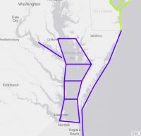
en-US TROPICAL STORM WARNING IS IN EFFECT ...TROPICAL STORM WARNING IN EFFECT... A TROPICAL STORM WARNING MEANS TROPICAL STORM WIND CONDITIONS ARE EXPECTED SOMEWHERE WITHIN THIS AREA AND WITHIN THE NEXT 36 HOURS * LOCATIONS AFFECTED - ST MARYS CITY * WIND - LATEST LOCAL FORECAST: BELOW TROPICAL STORM FORCE WIND - PEAK WIND FORECAST: 20-30 MPH WITH GUSTS TO 45 MPH - CURRENT THREAT TO LIFE AND PROPERTY: ELEVATED - REMAIN BRACED AGAINST THE REASONABLE THREAT FOR TROPICAL STORM FORCE WIND OF 39 TO 57 MPH.
Attachments
Chris0nllyn
Well-Known Member
Slowly tracking back north at the tail end of the 72 hour forecast.
Yesterday's forecast had it going out to the ocean, then the 8am model showed it tracking more north, and now the 11am model shows it even more north, adding the watches posted above.
I'd like to see this afternoon's model and see if it shifts north any more.
Yesterday's forecast had it going out to the ocean, then the 8am model showed it tracking more north, and now the 11am model shows it even more north, adding the watches posted above.
I'd like to see this afternoon's model and see if it shifts north any more.
Grumpy
Well-Known Member
I'd like to see this afternoon's model and see if it shifts north any more.
Wouldn't less weather be preferable??
GWguy
*
Wouldn't less adverse weather be preferable??
:fixed: I kinda like weather, especially the sunny, cool, dry days.

GWguy
*
who has bread, milk and TP?

All stocked up, even got some challah bread for french toast one morning this weekend.
Fired up the spare fridge and freezers "just in case". I can run all of that off the generator.