Ts Warning Now

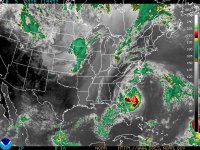
Is anyone following this on radar? Does it appear that Hanna is coming/forming back together as it is crossing the warmer waters? :confused:

Not yet. Hard to tell on radar. The text is more infomative.


HANNA IS NOW MOVING TOWARD THE NORTH NEAR 20 MPH. THIS GENERAL
MOTION IS EXPECTED TO CONTINUE FOR THE REST OF THE DAY. A TURN
TOWARD THE NORTHEAST WITH AN INCREASE IN FORWARD SPEED IS EXPECTED
ON SATURDAY. ON THE FORECAST TRACK...THE CENTER OF HANNA WILL PASS
ABOUT 60 MILES TO THE EAST OF WASHINGTON DC SATURDAY EVENING.

MAXIMUM SUSTAINED WINDS HAVE INCREASED TO NEAR 70 MPH...WITH
HIGHER GUSTS. ALTHOUGH NO SIGNIFICANT CHANGE IN STRENGTH IS
FORECAST BEFORE LANDFALL...IT WOULD ONLY TAKE A SMALL INCREASE IN
WIND SPEED FOR HANNA TO BECOME A HURRICANE. WEAKENING IS EXPECTED
AFTER LANDFALL
 

The Oyster Guy

New Member
I don't know much about hurricanes, but to me, it looks like an eye is trying to form (i.e. intensifying).
 

Attachments

  • temp.jpg
    temp.jpg
    78.2 KB · Views: 53

vraiblonde

Board Mommy
PREMO Member
Patron
Well, where is it? I didn't water my maters today because Mother Nature was supposed to water them for me.

:mad:
 
they are opening the shelters at 8pm grrr I have to go work there till 10 am tomorrow........
 
Last edited:

terbear1225

Well-Known Member
at what point would/should you head`to a`shelter? i don't forsee us going to one, flooding isnt a concern where we are, just curious for others. it seems like by the time you know you need to go, it would be too late.
 

KMPaddy2255

New Member
The radar on weather.com shows it raining in Lex. Park. Anyone know? Suppose to go to a company picnic tonight at Six Flags, and if it is moving that quick I'm going to go home instead. TIA
 
Tropical Storm Hanna Update


The Board of County Commissioners is closely monitoring the track of Tropical Storm Hanna.

Currently the National Weather Service is predicting that St. Marys County will receive 3-6 inches of rain with the potential for up to 10 inches in localized areas. Rainfall will begin this evening, with the heaviest rain expected from 6:00 AM to 4:00 pm on Saturday, September 6, 2008. Expect winds to be a sustained 20-30 MPH with gusts up to 50 MPH. Expected tides will be between 1ft. to 3ft. above astronomical high tide. High tide at Point Lookout, MD is expected to be Saturday at 6:05 AM and again at 7:23 PM.

St. Marys County will be opening Leonardtown High School as an emergency shelter beginning at 8:00 PM, Friday, September 05, 2008. Pets can be brought to the shelter and Animal Control will be able to shelter them outside. Please remember to bring food for your pets.

As TS Hanna develops please stay tuned to your local radio and television stations for further updates and warnings from the National Weather Service and St Marys County Government.

For more information about what you can do to prepare, visit the St. Marys County Department of Public Safety website at St. Mary's County Department of Public Safety - Homepage. Current information will be updated on the Emergency Information Hotline at 301-475-4911 and on County Channel 95.
 
Last edited:

Penn

Dancing Up A Storm
Yup. Started dripping about 10 min ago, light rain now in Town Creek.

We're supposed to have 20 - 30mph winds, with gusts up to 50mph?

No sign of that here - yet. :whistle: Just light to medium rain. :shrug:
 
Top