What's the situation up there, you all getting some winter weather? Am I going to have to get up at 5am to do closing posts?

You are using an out of date browser. It may not display this or other websites correctly.
You should upgrade or use an alternative browser.
You should upgrade or use an alternative browser.
Smow
- Thread starter vraiblonde
- Start date
kwillia
n/a
Tonight's path is a blow by from the west and we aren't expecting much of anything since they've already pre-treated the roads and the true cold blast isn't settling in until Friday night.What's the situation up there, you all getting some winter weather? Am I going to have to get up at 5am to do closing posts?
Now Friday night through Saturday is coming from the south and the below freezing temps should already be in place so St. Mary's is looking good for a chance of measurable, plow able accumulation...
 counties north of us may end up with a flurry if that.
kwillia
n/a
From the south I said... so lookie here...
Myrtle Beach, SC Saturday into Saturday night:
Day
38°Hi
RealFeel® 24°
Precipitation 68%
Windy and colder; rain and sleet in the morning followed by snow and sleet in the afternoon
Night
23°Lo
RealFeel® 9°
Precipitation 25%
Breezy early; otherwise, partly cloudy and colder; slushy areas and standing water will freeze
http://www.accuweather.com/en/us/myrtle-beach-sc/29577/daily-weather-forecast/340581?day=3
GregV814
Well-Known Member
ABANDON ALL HOPE NOW!!!! ABANDON YOUR CARS, TORCH YOUR STOCK CERTIFICATES FOR WARMTH!!!! GO TO THE LOCAL 7-11 LIKE A LUNATIC AND BUY BATTERIES, TP BREAD AND KEROSENE!!! EVACUATE NOW....WE MAY GET 1/4 OR SNOW!!!! And you ask why our precious snowflakes need coddling over an election?????

From the south I said... so lookie here...
Myrtle Beach, SC Saturday into Saturday night:
Day
38°Hi
RealFeel® 24°
Precipitation 68%
Windy and colder; rain and sleet in the morning followed by snow and sleet in the afternoon
Night
23°Lo
RealFeel® 9°
Precipitation 25%
Breezy early; otherwise, partly cloudy and colder; slushy areas and standing water will freeze
http://www.accuweather.com/en/us/myrtle-beach-sc/29577/daily-weather-forecast/340581?day=3
We're in Charleston, but it's the same forecast (without the snow and sleet). The weather here is SUPER bipolar - all four seasons in one week.

RareBreed
Throwing the deuces
well, the DC Snow Whores (I'm looking at you, Tenacious Topper) were getting up there for tomorrow, I think 3-5 is it.
I heard Northern/Central Calvert 1-3 inches. Southern Calvert/St Mary's 4-6+ inches.
awpitt
Main Streeter
As long as it doesn't reach BWI too bad I'm fine with it. I have to take my son to the airport early tomorrow morning for his flight back to his ship in Cali. Not worried about driving up. Only hoping the flights don't get messed up.
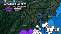
Winter Storm Warning
URGENT - WINTER WEATHER MESSAGE
NATIONAL WEATHER SERVICE BALTIMORE MD/WASHINGTON DC
713 AM EST FRI JAN 6 2017
MDZ017-062015-
/O.UPG.KLWX.WS.A.0001.170107T0600Z-170108T0000Z/
/O.NEW.KLWX.WS.W.0001.170107T0600Z-170108T0000Z/
ST. MARYS-
713 AM EST FRI JAN 6 2017
...WINTER STORM WARNING IN EFFECT FROM 1 AM TO 7 PM EST
SATURDAY...
THE NATIONAL WEATHER SERVICE IN BALTIMORE MD/WASHINGTON HAS
ISSUED A WINTER STORM WARNING FOR SNOW...WHICH IS IN EFFECT FROM
1 AM TO 7 PM EST SATURDAY. THE WINTER STORM WATCH IS NO LONGER IN
EFFECT.
* PRECIPITATION TYPE...SNOW.
* ACCUMULATIONS...SNOW ACCUMULATION OF 3 TO 6 INCHES.
* TIMING...LATE TONIGHT THROUGH SATURDAY AFTERNOON.
* IMPACTS...SNOW ON ROADS WILL RESULT IN SIGNIFICANT TRAVEL
IMPACTS.
* WINDS...NORTH 10 TO 15 MPH WITH GUSTS UP TO 25 MPH.
* TEMPERATURES...IN THE MID 20S.
PRECAUTIONARY/PREPAREDNESS ACTIONS...
A WINTER STORM WARNING FOR HEAVY SNOW MEANS SEVERE WINTER WEATHER
CONDITIONS ARE EXPECTED OR OCCURRING. SIGNIFICANT AMOUNTS OF SNOW
ARE FORECAST THAT WILL MAKE TRAVEL DANGEROUS. ONLY TRAVEL IN AN
EMERGENCY. IF YOU MUST TRAVEL...KEEP AN EXTRA FLASHLIGHT...
FOOD...AND WATER IN YOUR VEHICLE IN CASE OF AN EMERGENCY.
&&
$$
JACKSON
RareBreed
Throwing the deuces
As long as it doesn't reach BWI too bad I'm fine with it. I have to take my son to the airport early tomorrow morning for his flight back to his ship in Cali. Not worried about driving up. Only hoping the flights don't get messed up.
I always wondered why Southern Calvert was never put under the same Warnings/Watches when St Mary's and the lower part of the Eastern shore were. Found out counties can't be placed under those unless the WHOLE county will be effected by it. So basically, Since the Central and Northern counties won't get as much, Calvert is eliminated but Southern Calvert Co is technically under the same Warning as St Mary's.
Attachments
awpitt
Main Streeter
I always wondered why Southern Calvert was never put under the same Warnings/Watches when St Mary's and the lower part of the Eastern shore were. Found out counties can't be placed under those unless the WHOLE county will be effected by it. So basically, Since the Central and Northern counties won't get as much, Calvert is eliminated but Southern Calvert Co is technically under the same Warning as St Mary's.
Geographically, So. Calvert will be impacted by the same weather as St. Mary's; however, technically So Calvert isn't under the warning. Although, it should be.
RareBreed
Throwing the deuces
Geographically, So. Calvert will be impacted by the same weather as St. Mary's; however, technically So Calvert isn't under the warning. Although, it should be.
Yep, that's why I posted the reasoning behind why it isn't.
